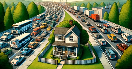
Why your street is big enough to land an airplane
You should know about the oh-so-important traffic analysis that ruins neighborhood character
A stated position is “not in my backyard” or “yes, in my backyard.” A shared interest is “great neighborhood character.” That’s right, even NIMBYs and YIMBYs have shared interests. The two might disagree vehemently about whether townhomes should be legal on the same street as single-family homes, but they both want to live in a great place.
There are many ways land use and transportation policies shape a community. Traffic analysis is one that slips through the cracks of housing discussions, but it’s a powerful tool you should keep top of mind.
Level of Service (LOS) is how traffic engineers justify monstrous intersections like the one below. LOS has nothing to do with safety, but it's the driving force behind traffic analysis.
Transportation engineers use LOS to assess vehicular traffic flow. It's rated like a school report card from A (free flow) to F (congested). If you only remember two things about LOS, remember:
LOS measures how long drivers sit at an intersection, and
LOS does not measure safety.
Those two facts are not in dispute, but it’s rare for transportation professionals to admit the second. It’s of course possible for mobility experts to analyze vehicular traffic and evaluate the safety of a system. What I want to emphasize is that LOS has nothing to do with safety, and yet it’s the primary reason intersections like the one above exist everywhere.
The Highway Capacity Manual, a cornerstone of transportation engineering, was first published in 1950 by the Highway Research Board (now known as the Transportation Research Board). Its purpose was to standardize methodologies for assessing the capacity and performance of highways for the post-World War II United States. Keep in mind car infrastructure was fairly new, so it makes sense that experts would develop ways to measure car traffic.
The first edition hit the shelves in 1950 and primarily focused on rural highways. At the time, the US was linking cities across the country with highways in case the Soviets attacked. Fifteen years later, the second edition of the Highway Capacity Manual was published, and it began to address the complexities of urbanized areas. This is where LOS emerged as the industry standard for analyzing the movement of vehicles through intersections, not just highways.
From the time it emerged in the 1960s, LOS has never been a tool to analyze safety. LOS measures the average delay per vehicle at intersections. Here's a handy chart that a traffic engineer might keep on their desk.
When LOS is determined to be "unacceptable" (typically D, E, or F), it triggers road "improvements." Of course I’m using quotation marks deliberately. Unacceptable and improvements are subjective, because the outcome of a LOS analysis is typically adding lanes and increasing intersection size to reduce delays for vehicles. Any increase in crashes isn't considered, because LOS isn't analyzing intersection safety.
To add insult to injury, LOS is used like a fortune teller's crystal ball. Engineers, with a straight face, predict the number of cars going every which way at intersections 20 years from now. They apply LOS analysis to prove traffic will be unacceptable if we don’t expand the intersections.
So-called improvements to mitigate the LOS predictions often result in property takings. Homes, businesses, and community spaces are demolished, leading to displacement of residents and loss of neighborhood character. People suffer as their quality of life diminishes with the increase of vehicle traffic, vehicle speed, and vehicle crashes. That’s why I want NIMBYs to understand traffic engineering is their worst nightmare. A neighborhood street converted to a highway? Not in my backyard!
I suppose there might be a few traffic engineers roaming Google Street View looking for intersections to expand for no reason at all. But that has to be rare. Check out your local planning department to see why LOS is performed so often and used to obliterate neighborhoods. They not only allow LOS analysis, they demand it.
Local rules for development, redevelopment, zoning, etc. include traffic analysis. Planners require traffic engineers to predict the future, apply LOS analysis, and plan infrastructure to guarantee that vehicle traffic won’t have to slow down too much at intersections. Do some internet searches for “when do I need a traffic impact study” and “development traffic study” and “[my town/county/city] rules for traffic impact analysis.” Be prepared to have your mind blown.
LOS is the transportation industry standard for analyzing intersections, and it has nothing to do with safety. It's been used for decades to ruin the neighborhood.


Great article thanks I’ve always suspected the truth was something like and was good to have my “we need reeducation camps for traffic engineers” biases confirmed.
Not sure if you know anything about this but I’d love to see some scrutiny (or an article perhaps?) put on the traffic generation rates these engineers ascribe to new land uses.
So say a new apartment building is proposed, as part of a traffic study they predict that the building will generate X cars in order to predict their impact on the network.
These have always seemed incredibly arbitrary to me and I’ve always suspected they were based on very thin assumptions.
Traffic engineers are trained at university Schools of Engineering. The primary traffic engineering department for the State of Virginia- Virginia Tech- doesn’t offer a single second of instruction on non-motorized roadway design and usage. I suspect most other engineering schools are similar.